
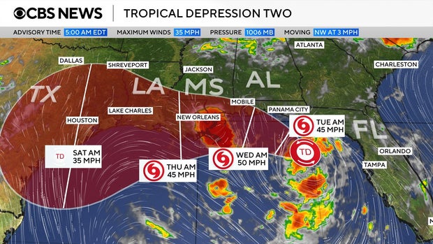
Tropical Storm Bertha formed on Monday, posing a threat to the Gulf Coast with significant rainfall. It is the second named storm in the Atlantic hurricane season. Currently, the storm is situated south of the Florida Panhandle, carrying maximum sustained winds of 40 mph, according to the National Weather Service. The storm is slowly moving west-northwest at approximately 3 mph.
Forecast and Path
A map of the storm, initially known as Tropical Depression Two, reveals its projected path along the Gulf Coast. It is expected to move west from the Panhandle and reach the New Orleans vicinity and later eastern Texas within the week. On Monday, Tropical Depression Two intensified into Tropical Storm Bertha.
“A slow northwestward motion is expected through tonight, followed by a turn toward the west-northwest or west,” the National Weather Service stated. “On the forecast track, the depression will move near or along the northern Gulf coast during the next several days.”
Warnings and Watches
A Tropical Storm Watch has been issued for regions extending from the Ochlockonee River in Florida to the Jefferson/Plaquemines Parish border in Louisiana. Moreover, a Storm Surge Watch spans from the Alabama/Florida border to the mouth of the Mississippi River.
Forecasters caution that some areas might experience rainfall reaching up to 8 inches. The precipitation is anticipated to persist through the week, affecting the Gulf Coast and nearby inland regions from western Florida to the Texas coast. Alabama, Mississippi, and Louisiana are also in the storm’s path, with potential flash flooding as a consequence of the rain.
In addition to heavy rain, the system could trigger storm surge, causing water levels to rise up to 4 feet in specific areas along the Gulf Coast. Bertha’s appearance follows weeks after Tropical Storm Arthur, the first named storm of the 2026 hurricane season, which made landfall in June along the Texas Gulf Coast.