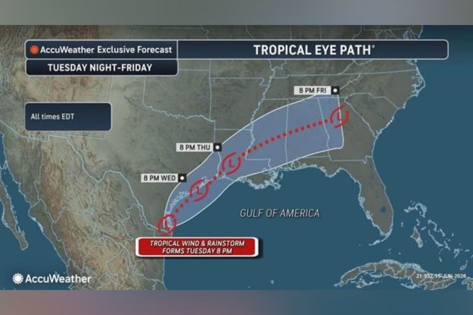
Millions across the Gulf Coast and Lower Mississippi Valley face the threat of severe flash flooding this week. A weather system near Texas has the potential to develop into a tropical storm briefly, raising concerns among forecasters. Currently, this disturbance brings widespread showers and thunderstorms near the Texas-Mexico border. The influx of tropical moisture could result in several days of substantial rainfall.
Potential Tropical Storm Formation
If the disturbance evolves into a tropical storm, it will be named Arthur. Forecasters emphasize that the primary danger stems not from wind strength but from the significant rainfall. Recurrent heavy downpours may overwhelm drainage systems, causing dangerous flash floods and rapid river rises in already saturated regions.
System Predictions and Warnings
An update from the National Hurricane Center (NHC) on Tuesday morning described a low-pressure trough near the Mexico-Texas border. This system is producing a broad area of disorganized showers and thunderstorms. Forecasts suggest it could reemerge over the northwestern Gulf of America, where conditions might support the formation of a short-lived tropical storm by late Tuesday or Wednesday.
Irrespective of tropical cyclone development, the NHC advises residents in southern and eastern Texas, as well as parts of Louisiana and Mississippi, to brace for intense rainfall in the upcoming days. This could lead to widespread, severe flash, urban, and river flooding. Additionally, gusty winds and coastal flooding might impact sections of the northwestern Gulf Coast. Tropical storm watches or warnings could be issued if the system progresses.
Flooding Concerns
An email from AccuWeather to Newsweek highlighted the possibility of a “tropical rainstorm” forming on Tuesday. This term is used for tropical systems that might not earn an official name but still pose significant flooding threats. Dan DePodwin, AccuWeather’s vice president of forecasting operations, cautions that repeated torrential rains this week—fueled by tropical moisture—could lead to major flash floods.
Areas at Greatest Risk
AccuWeather forecasts suggest the system may deliver heavy rain from eastern Mexico through Texas and parts of the Gulf Coast, moving northeastward as the week progresses. Rainfall rates could reach 2 to 4 inches per hour during intense storms, heightening the chance of rapidly rising water, especially in urban areas like Houston.
Monitoring and Predictions for Storm Arthur
As of Tuesday, the National Weather Service has issued flood watches for southern and southeastern Texas, much of Louisiana, and around the southern half of Mississippi. The Atlantic hurricane season, officially starting on June 1 and lasting through November, is anticipated to be below-normal this year. The National Oceanic and Atmospheric Administration predicts between eight and 14 named storms in total. The NHC continues to observe the disturbance and will provide consistent updates online as the situation evolves.