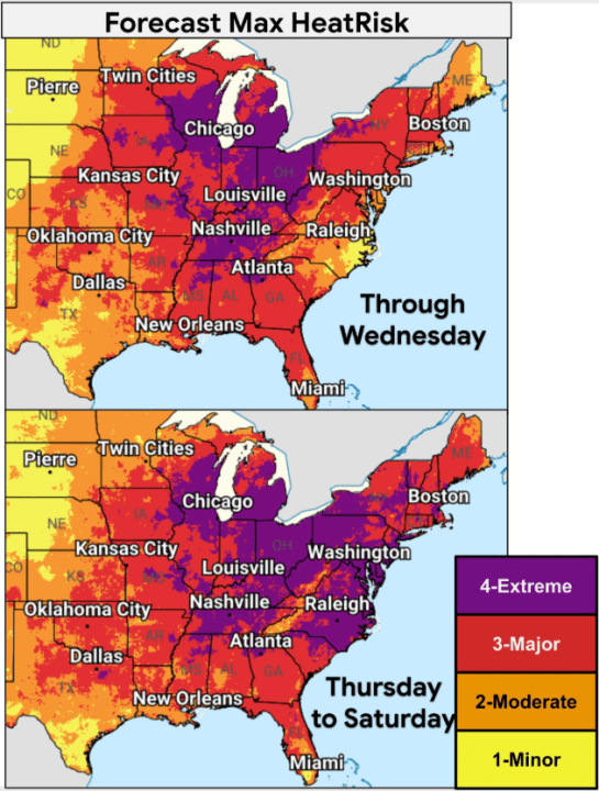
Communities across the central and eastern United States are grappling with extreme heat, marked by a potentially deadly heat wave. This surge in temperature is particularly concerning as it coincides with high humidity levels just before the July Fourth holiday.
According to Chief Meteorologist Brian James from Nexstar, the heat index – which combines air temperature and humidity – is expected to range between 105°F and 115°F in certain areas. Earlier this week, the Midwest and South experienced heat indices in triple digits, with cities like Chicago and Minneapolis registering over 100°F.
The National Weather Service (NWS) forecasts sustained high temperatures, many exceeding 100°F, across regions including the lower Great Lakes, the mid-Atlantic, and the Mississippi and Ohio River valleys. Meteorologist Bryan Putnam anticipates record-breaking highs this week in areas stretching from the lower Great Lakes to the mid-Atlantic and New England.
Major cities celebrating World Cup matches and America’s 250th anniversary, including New York, Philadelphia, Washington, Baltimore, Chicago, Indianapolis, St. Louis, and Detroit, are expected to endure soaring temperatures. Southern cities like Dallas, Little Rock, and Memphis will also experience intense heat.
The National Weather Service has projected record heat for several cities across the country:
Wednesday:
- Binghamton, NY – 91°F (Previous Record: 90°F, 2018)
- Burlington, VT – 97°F (Previous Record: 96°F, 2018)
- Cleveland, OH – 97°F (Previous Record: 95°F, 2002)
- Washington Dulles, VA – 100°F (Previous Record: 96°F, 2012)
- Manchester, NH – 98°F (Previous Record: 97°F, 1971)
Thursday:
- Albany, NY – 99°F (Previous Record: 98°F, 1966)
- Boston, MA – 101°F (Previous Record: 98°F, 1963)
- Charlottesville, VA – 104°F (Previous Record: 100°F, 1954)
- Washington D.C. National Airport – 103°F (Previous Record: 101°F, 1898)
- Philadelphia, PA – 104°F (Previous Record: 103°F, 1901)
Friday:
- Charlottesville, VA – 103°F (Previous Record: 100°F, 1966)
- Baltimore Downtown, MD – 104°F (Previous Record: 102°F, 1997)
- Richmond, VA – 101°F (Previous Record: 100°F, 1954)
- Tri-Cities, TN – 99°F (Previous Record: 96°F, 2018)
- Lynchburg, VA – 98°F (Previous Record: 97°F, 2012)
Saturday:
- Charlottesville, VA – 101°F (Previous Record: 100°F, 2012)
- Greensboro, NC – 99°F (Previous Record: 98°F, 1970)
- Richmond, VA – 102°F (Previous Record: 100°F, 2002)
- Roanoke, VA – 100°F (Previous Record: 99°F, 1999)
- Trenton, NJ – 100°F (Previous Record: 99°F, 2010)
Understanding the Heat Dome
A phenomenon known as a ‘heat dome’ is responsible for this extreme weather. It is a high-pressure system that traps heat by causing air to sink. According to the NOAA, this prevents convection and the formation of clouds that would offer relief, allowing heat to build continuously at the surface, resulting in a heat wave.
This high pressure also diverts storms, reducing the likelihood of cooling summer thunderstorms.
Safety Recommendations
The NWS advises caution, particularly for vulnerable groups such as young children, older adults, individuals with chronic conditions, and pregnant women.
Experts recommend staying hydrated, taking breaks in shaded areas, limiting intense outdoor activities, and ensuring children or animals are not left in parked vehicles.