
The current year’s El Niño is poised to be the strongest ever recorded, presenting challenges in comparing it to past events. Columbia University climate scientist Azhar Ehsan noted during a September media briefing that the atmospheric conditions this year mirror those of 1997, a year when a potent El Niño developed. According to an April 1998 report from the National Climatic Data Center, the winter of 1997-1998 was marked by unprecedented weather patterns and extremes. It was the second-warmest and seventh-wettest winter in the United States since 1895.
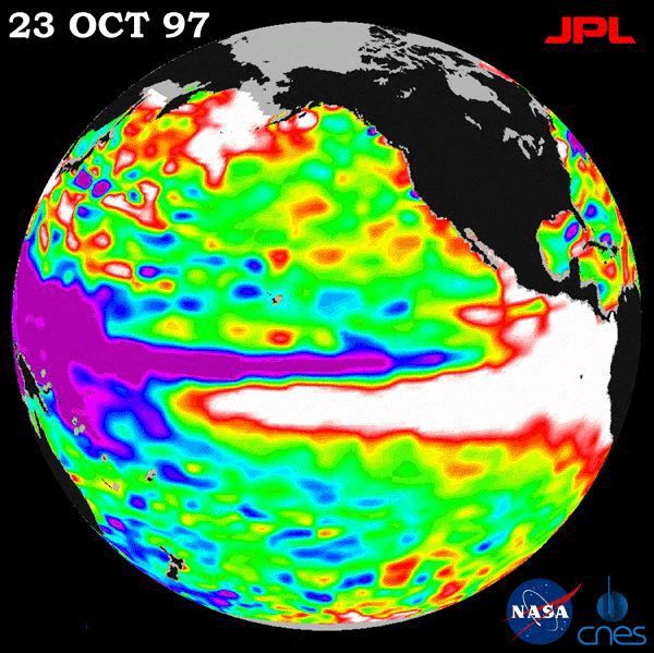
During this period, El Niño led to erratic weather nationwide. Ice storms impacted the Northeast, while the Southeast and California experienced heavy rainfall and flooding. Florida was plagued by severe tornadoes. A photo released by NASA in October 1997 illustrated the rising sea surface height due to El Niño’s influence, showcasing the white regions where warm water moved north along the North American coast.
El Niño typically results in wetter conditions for the southern regions of the U.S. and warmer, drier conditions for the northern states. The winter of 1997-1998 experienced generally warm and wet conditions across much of the country. California and North Dakota recorded their wettest winters ever, while states such as Florida, Maryland, Nevada, Rhode Island, and Virginia experienced their second-wettest winters. Florida alone received over 15 inches of rain in Tampa during December. January brought more than 19 inches of rain to New Orleans, 17 inches to Mobile, Alabama, and 10 inches to Asheville, North Carolina.
Early January brought severe storms, resulting in flooding, ice storms, and tornadoes across eastern North America. These events resulted in 56 deaths throughout the U.S. and Canada, with hundreds of homes destroyed and millions without power. The following month, California and the Southwest endured a prolonged period of storms, leading to mudslides and widespread flooding. In areas with less severe rainfall, persistent cloud cover was noted. Des Moines, Iowa experienced an 11-day stretch of cloudy weather in December, and Albuquerque, New Mexico saw no sunshine as Christmas approached.
People accustomed to cold winters faced unusually warm temperatures. February of that year set records for the warmest month in regions such as the upper Midwest and parts of the East, including Minnesota, Wisconsin, Illinois, Michigan, Ohio, Pennsylvania, and Connecticut. Northern Montana recorded no sub-freezing temperatures in December 1997, and by the end of February, Lake Erie at Buffalo remained unfrozen with a water temperature of 36 degrees Fahrenheit. A notable benefit from the unusual weather was a 10% reduction in heating costs nationwide.
The forecast for the 2026-2027 period suggests a stronger El Niño compared to the 1997-1998 event. Predictions indicate its impact may include droughts in certain areas, flooding in others, and up to 451,000 weather-related deaths globally. A pronounced El Niño increases the likelihood of warmer, drier northern regions and colder, wetter southern regions. The location of this division varies each year, influenced by the jet stream’s position.
Currently, El Niño’s intensity has been building since its emergence in the summer. National forecasters predict a 75% chance of experiencing an event surpassing those recorded since 1950. Although El Niño typically reaches peak strength in winter months, its influence has been apparent in recent summer and fall weather patterns. One example is the subdued Atlantic hurricane season contrasted by heightened storm activity in the Pacific. Temperature and precipitation predictions for the remainder of the year align with traditional El Niño patterns.