
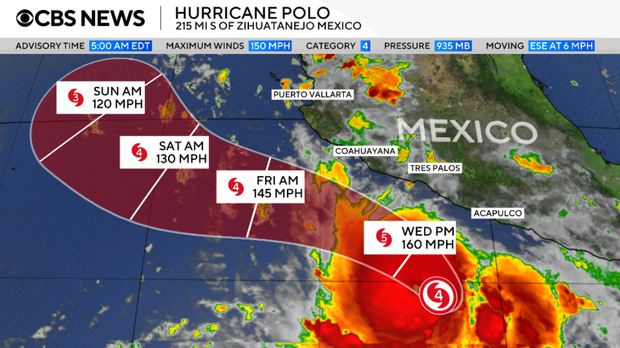
Hurricane Polo intensified sharply off southwestern Mexico’s coast on Tuesday, transforming into a Category 5 storm. This escalation raised alarms about potential life-threatening floods in Guerrero and Michoacán, according to the National Hurricane Center.
By Tuesday morning, Polo’s maximum sustained winds increased from 150 mph to 160 mph, attaining Category 5 status. The hurricane center noted the storm might gain strength further through Wednesday.
At 6 a.m., Polo was positioned approximately 220 miles south of Zihuatanejo in Guerrero and 360 miles south-southeast of Manzanillo in Colima. It moved eastward near Mexico’s Pacific Coast at 6 mph.
“Rainfall may produce life-threatening flooding and mudslides, especially in areas of steep terrain.”
A tropical storm watch applied to the Mexican coast from Tecpan de Galeana in Guerrero to Manzanillo. Such watches are issued when meteorologists anticipate tropical storm conditions in the region within 48 hours.
Forecasters predicted Polo would maintain its current trajectory before sharply turning northwest on Tuesday night and Wednesday. This change could bring the hurricane’s core near the southwestern coast soon. Though forecasted to stay offshore, Polo would likely deliver substantial rainfall, and possibly trigger dangerous flooding and mudslides in coastal areas, particularly over steep terrain.
Guerrero and Michoacán might see 4 to 8 inches of rainfall, with certain spots receiving up to 12 inches, through Thursday. Coastal areas in Oaxaca, Colima, and Jalisco could experience 3 to 6 inches of rain by Thursday, forecasters added.