
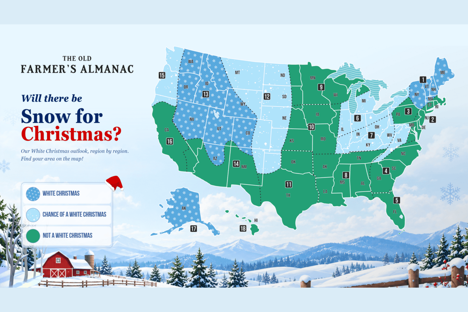
According to a new long-range forecast by The Old Farmer’s Almanac, Americans looking for a white Christmas in 2026 have the best chances in three regions: the Northeast, Intermountain region, and Alaska. These places are predicted to have snow on the ground come Christmas morning. Other regions including the Pacific Northwest, High Plains, Lower Lakes, and Ohio Valley also have a chance, although the outlook varies.
In contrast, many areas such as the South and central United States may not see any snow on Christmas. The Atlantic Corridor, Southeast, Florida, Deep South, Upper Midwest, Heartland, Texas-Oklahoma, and parts of the Southwest are not expected to experience a white Christmas. Hawaii is also anticipated to miss out.
A white Christmas is defined as having at least 1 inch of snow on the ground at 7 am local time on Christmas Day.
Throughout the Appalachians, the forecast differs: northern areas are unlikely to see snow, whereas southern parts might just have a chance. It’s important to note that snow does not need to fall on December 25; earlier snowfall can count if at least an inch is still present.
Why Some Regions Have Better Prospects
Regions likely to see a white Christmas often coincide with those expecting above-normal snowfall this winter. This includes the Northeast, parts of the Appalachians, the Intermountain region, and Alaska. For instance, southern areas of the Northeast should see significant snow by mid-to-late December.
The Intermountain region could receive more snow than usual, increasing its chances of a white Christmas. However, the Pacific Northwest might only have a chance despite predicted above-normal snowfall levels.
Carol Connare, editor-in-chief of The Old Farmer’s Almanac, remarks that “winter won’t look the same everywhere.” While many parts of the country may face milder conditions, significant snowfall is still anticipated in some areas.
Understanding The Old Farmer’s Almanac
The Old Farmer’s Almanac, operating since 1792, began as a practical tool for farmers. It uses solar science, climatology, meteorology, historical weather patterns, current solar activity, climate data, and large-scale climate signals to develop forecasts. These predict weather trends, not exact conditions months in advance.
The NWS’s Climate Prediction Center provides official long-range climate outlooks. These eight-to-14-day, monthly, and seasonal outlooks indicate temperature and precipitation probabilities without giving precise weather predictions.
The Almanac’s white Christmas forecast serves as an early hint of areas likely to have snow on December 25. As December approaches, short-term forecasts will provide a clearer picture.
Historical Data on Snow Patterns
Historic data from the National Oceanic and Atmospheric Administration (NOAA) aligns with the Almanac’s forecasts. It shows that Minnesota, Maine, upstate New York, Idaho, and many mountain regions commonly have at least an inch of snow on Christmas morning. Alaska typically experiences a white Christmas, contrasting with much of the continental U.S.
Experts caution that historical probabilities offer guidance but conditions can vary yearly due to immediate pre-Christmas weather. Thus, the current outlook may change as December nears.