
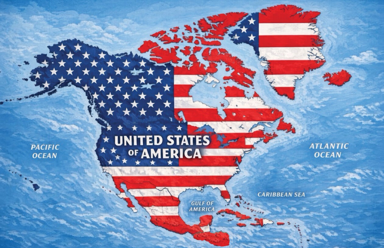
President Trump’s Controversial Map
President Donald Trump shared an AI-generated map on social media, presenting an expanded United States that includes major parts of North America. This image posted on Truth Social shows the U.S. flag placed over countries such as Canada, Mexico, Greenland, Cuba, and other territories. Without any accompanying caption or explanation, the post has not been identified as part of any formal policy change by the White House.
Geographical Implications
The map’s coverage extends over the entire North American continent, which consists of 23 sovereign nations, Greenland, an autonomous territory under Denmark, and several Caribbean territories. Trump’s previous remarks have hinted at redefining political boundaries, including ideas such as Canada becoming the 51st U.S. state and incorporating Greenland into the U.S. territory. His administration has strained relations with Mexico and Cuba over political differences.
International Responses
Several countries depicted in the image have voiced opposition to Trump’s territorial ambitions, though not directly addressing Monday’s post. Canadian Prime Minister Mark Carney, in discussions with Trump, opposed the notion of Canada joining the U.S. He firmly stated, “As you know from real estate, there are some places that are not for sale,” to which Trump replied, “Never say never.” Mexican President Claudia Sheinbaum, defending her country’s sovereignty, posted on social media that Mexico will remain free, independent, and not a colony.
Cuba also criticized U.S. policies, with Foreign Minister Bruno Rodríguez accusing the Trump administration of collective punishment through energy blockades and sanctions. He noted severe power outages impacting Cuban citizens.
Other Recent Provocations
Trump has shared other AI-generated images with equally provocative messages, suggesting the renaming of New Mexico as “New America” and claiming ownership over celestial bodies with posts like “The Moon Is Ours.” An executive order earlier this year aimed to change the name of the Gulf of Mexico to “Gulf of America” for U.S. federal matters, though it lacks international recognition. Most recently, Trump expressed intent to rename Lake Ontario as “Lake America” as part of trade conflicts with Canada.
Expert Insights
Political professor Craig Agranoff commented that such activities seem more like messaging rather than policy. He remarked, “President Trump often uses maps and renamed landmarks as political theater. Posting an image without text is classic provocation instead of a formal claim.” Agranoff noted that silence from international allies and neighbors could be seen as tacit acceptance, which might complicate diplomacy, trade, and security agreements.
Countries and Territories on Trump’s Map
- Canada
- United States
- Greenland – autonomous territory within Denmark
- Iceland
- Mexico
- Belize
- Guatemala
- Honduras
- El Salvador
- Nicaragua
- Cuba
- Jamaica
- Haiti
- Dominican Republic
- Bahamas
- Puerto Rico – U.S. territory
- Cayman Islands – British Overseas Territory
- Antigua and Barbuda
- Saint Kitts and Nevis
- Dominica
- Saint Lucia
- Barbados
- Saint Vincent and the Grenadines
- Turks and Caicos Islands – British Overseas Territory
- British Virgin Islands – British Overseas Territory
- U.S. Virgin Islands – U.S. territory
- Saint-Martin – French overseas collectivity
- Sint Maarten – constituent country within the Kingdom of the Netherlands
- Anguilla – British Overseas Territory
- Saint Barthélemy – French overseas collectivity
- Montserrat – British Overseas Territory
- Guadeloupe – French overseas department and region
- Martinique – French territorial collectivity
- Grenada
- Other Caribbean countries and territories like Trinidad and Tobago, Aruba, Bonaire, and Curaçao