
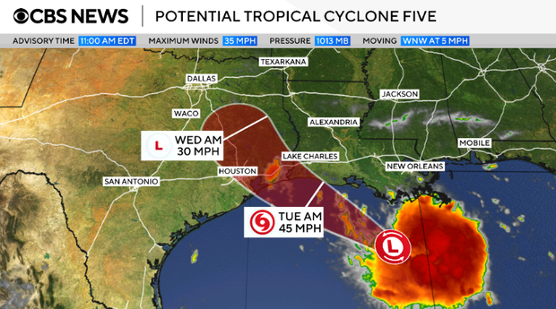
A tropical storm warning was declared for coastal areas of Louisiana and Texas. This follows the emergence of a potential tropical cyclone in the Gulf. This system marks the fifth development of its kind in the 2026 Atlantic hurricane season. The National Hurricane Center has initially identified it as Potential Tropical Cyclone Five. If it progresses as expected, it will be named Tropical Storm Edouard.
Rainfall Predictions and Impact
Forecasters expect the system to deliver 3 to 6 inches of rain across coastal Texas and certain inland regions in the east-central part of the state. Some areas may experience up to 9 inches. Southwestern Louisiana could see rainfall amounts of 2 to 3 inches, according to the National Hurricane Center. These rainfalls pose a risk of flash flooding, particularly in low-lying and urban regions. Additionally, storm surge may reach up to 3 feet in coastal areas.
The warning covers parts of southeastern Texas and southwestern Louisiana, extending from Texas’ Port Bolivar to Louisiana’s Vermilion/Cameron Parish Line, as provided by the Miami-based hurricane center.
Tropical Storm Conditions Expected
Communities receive tropical storm warnings when strong winds, rain, and flooding are expected within the designated area. Current forecasts suggest these conditions may begin within 24 to 36 hours. The storm might impact the Gulf Coast as early as Tuesday.
On Monday morning, the storm moved slowly westward towards the Gulf Coast. Forecasters located it about 130 miles from Morgan City, Louisiana, and 230 miles from Port Arthur, Texas.
At 11 a.m. ET, maximum sustained winds were 35 mph, just shy of the 39 mph threshold for tropical storm classification. Experts anticipate some strengthening over the next day.