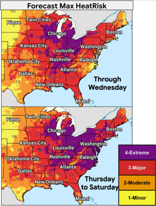
Communities throughout the central and eastern United States are dealing with a severe, record-breaking heat wave. This extreme heat, which coincides with high humidity levels, is increasing risks, especially with the July Fourth holiday approaching. According to Nexstar Chief Meteorologist Brian James, some areas could experience heat index values between 105 and 115 degrees Fahrenheit.
Areas across the Midwest and South already recorded heat indices surpassing the triple digits, including cities like Chicago and Minneapolis, where temperatures exceeded 100 degrees Fahrenheit. Several days of high temperatures are anticipated in regions such as the lower Great Lakes, the mid-Atlantic, and the Mississippi and Ohio River valleys.
Meteorologist Bryan Putnam from the National Weather Service (NWS) indicated that these high temperatures might set new record highs from the lower Great Lakes to New England later this week. Notably, several major cities are hosting World Cup matches and events celebrating America’s 250th anniversary during this period, including New York, Philadelphia, Washington, Baltimore, Chicago, Indianapolis, St. Louis, and Detroit. Southern cities like Dallas, Little Rock, and Memphis will also experience elevated temperatures.
The NWS projects specific cities to break daily heat records this week:
Wednesday: Binghamton, NY (91°F, prev. 90°F/2018); Burlington, VT (97°F, prev. 96°F/2018); Cleveland, OH (97°F, prev. 95°F/2002)
Thursday: Albany, NY (99°F, prev. 98°F/1966); Hartford, CT (102°F, prev. 99°F/1966); Boston, MA (101°F, prev. 98°F/1963)
Friday: Charlottesville, VA (103°F, prev. 100°F/1966); Baltimore, MD (104°F, prev. 102°F/1997); Richmond, VA (101°F, prev. 100°F/1954)
Saturday: Baltimore/Washington Int’l, MD (101°F, prev. 100°F/2002); Charlotte, NC (100°F, prev. 99°F/1993); Portland, ME (97°F, prev. 93°F/2018)
The heat wave is driven by a “heat dome” settled over the region. This high-pressure system leads to descending air, which traps heat near the surface. This process reduces convection, limiting cloud formation and rainfall. Consequently, temperatures rise continuously, intensifying the heat wave. Such systems also steer storms away, reducing chances for thunderstorms that could provide relief.
The NWS advises checking in on vulnerable individuals, such as young children, older adults, people with chronic conditions, and pregnant women. It’s crucial to remain hydrated, take breaks from the sun, avoid intense outdoor activities, and never leave children or animals in parked vehicles.