
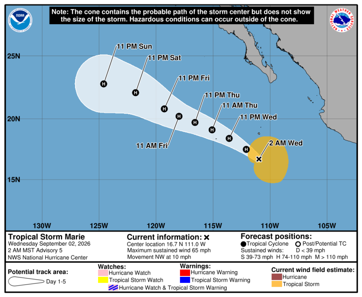
The course of Hurricane Marie remains unpredictable. However, forecasters indicate its possible effects on Southern California during the Labor Day weekend. Increased humidity, potential showers, and surf dangers are noteworthy.
Possible Impact Areas
Daniel Swain, a climate scientist from UC, noted that a hurricane-strength landfall in California is improbable. A direct tropical storm landfall has a mere 10% chance. Nonetheless, heavy rainfall and thunderstorms, with a risk of flooding, stand at 20% to 25% likelihood. There is also a similar chance for no rainfall at all. Some projections suggest Marie’s remnants could head toward Southern California, but most forecasts predict it will veer west toward open waters.
According to Robbie Berg from the National Hurricane Center, Marie is expected to move northwest, away from land. Yet, a slight possibility exists for Marie to shift further north, potentially impacting Southern California. As of Wednesday morning, Marie sustained winds of 70 mph. Located about 1,300 miles southeast of San Diego Tuesday night, Marie was anticipated to become a hurricane later on Wednesday, moving approximately 775 miles southwest by Sunday.
Rainfall Possibilities
The National Weather Service in Oxnard mentioned a low probability of moderate-to-heavy rain, posing flood risks alongside thunderstorms. However, there is a moderate chance of light rain possibly affecting outdoor plans and coastal flooding on south-facing shores. They advised preparing backup plans for potential wet events, particularly between Sunday and Tuesday. During this period, there’s a 50% to 60% likelihood of light rain and a 10% to 20% chance of moderate to heavy rainfall. Lesser amounts of rain, potentially less than 1 inch, are expected in San Diego, Orange, Riverside, and San Bernardino counties.
Similar wet conditions are anticipated in the San Joaquin Valley, Mojave Desert, and Sierra Nevada region. Although significant rainfall is unlikely north of the Central Coast, large swells might reach the Central Coast and Bay Area. The weather service highlighted an elevated risk of dangerous rip currents and large waves over the holiday weekend. Specifically, Sunday and Monday are expected to see peak wave activity. Visitors to beaches should ensure lifeguards are present.
Coastal Flooding Risks
The weather service pointed out the possibility of coastal flooding, though with less certainty. Large surf combined with high tides during Labor Day weekend into Tuesday might affect areas like Long Beach’s Alamitos Peninsula, Malibu, Point Mugu, Avalon on Catalina Island, and parts of Santa Barbara.
Fire Weather Concerns
Interestingly, Hurricane Marie might heighten fire weather risks before rainfall if specific conditions arise. This could lead to gusty offshore winds and increased wildfire danger, particularly in the Santa Ana and San Bernardino mountains, the Inland Empire, and surrounding counties. There is a 10% to 15% chance of moderate-to-strong easterly winds, which could risk downing trees and spreading wildfires. This setup draws parallels to fire weather conditions observed during the deadly Maui fire in 2023.
Remaining Alerts
Forecasters stress the importance of staying informed. Any slight shift in Marie’s direction might significantly alter the weather forecast.