
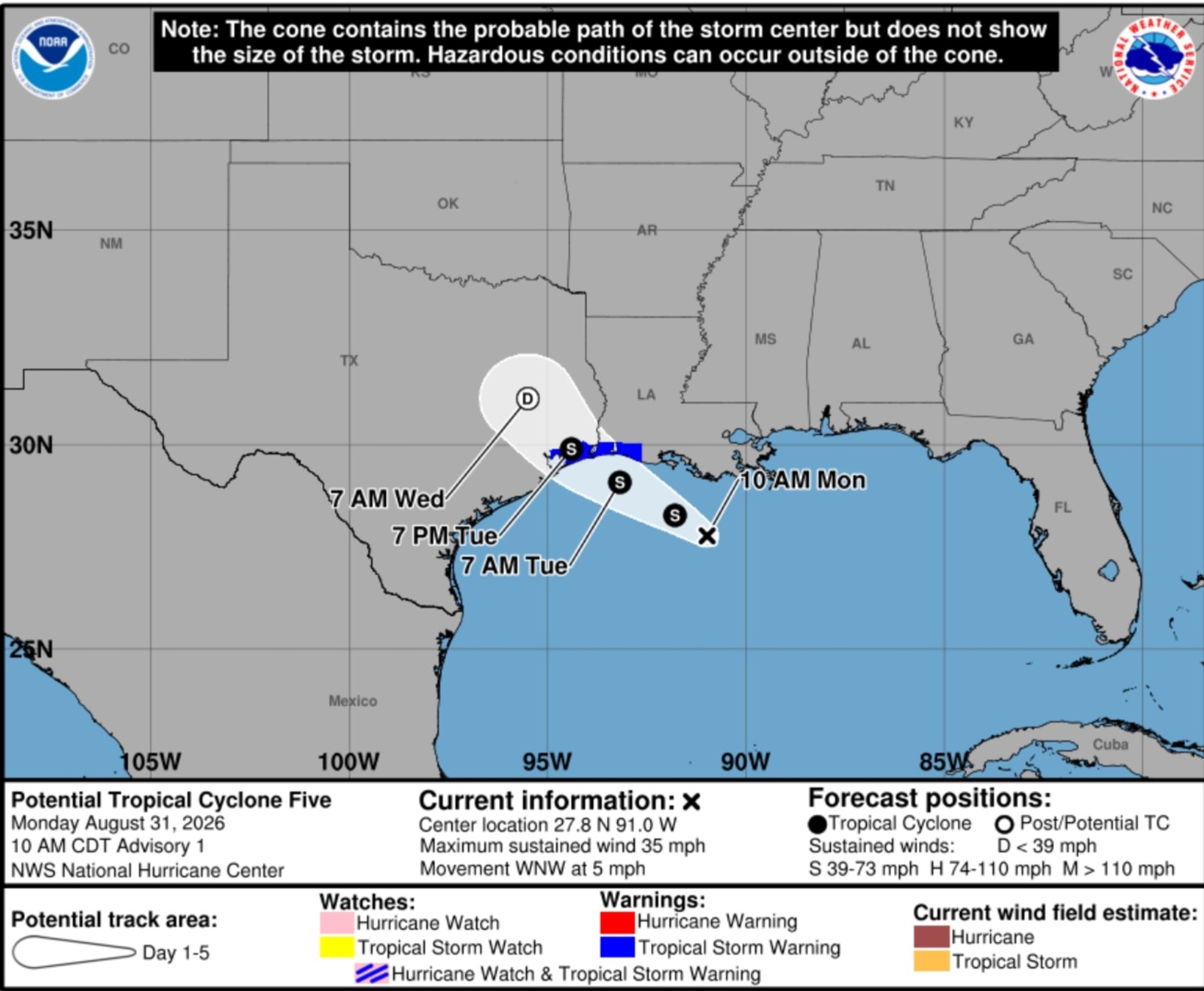
A tropical rainstorm is moving across the northern Gulf Coast, poised to bring significant rainfall, flash flooding, and travel disruptions to parts of Texas and Louisiana throughout the week. Meteorologists warn that some regions could experience several inches of rain in a brief period, leading to potential flash flooding. Though the system is not anticipated to evolve into a major wind event, the primary hazard remains the rainfall.
Advisories and Warnings
On Monday, the National Hurricane Center (NHC) began issuing advisories for Potential Tropical Cyclone Five, a disturbance in the northwestern Gulf producing sustained winds of 35 mph. Tropical storm warnings are in effect for areas along the upper Texas and southwestern Louisiana coasts as the system advances west-northwest at around 5 mph.
There is a possibility for the disturbance to gain strength before making landfall. AccuWeather suggests that the rainstorm may briefly organize into a tropical depression or storm before hitting the coast on Tuesday. However, significant intensification is unlikely. If it reaches tropical-storm strength, it would be named Edouard.
Rainfall Prediction and Impacts
The storm’s most intense rainfall is expected initially along coastal Louisiana before spreading west into southeastern Texas, which includes the Houston metropolitan area. Animated weather data from windy.com forecasts substantial rainfall in the days ahead across coastal Texas and Louisiana, with some locations expected to receive up to 9 inches.
“PTC Five is expected to produce rainfall totals of 3 to 6 inches, with peak amounts of 9 inches for parts of the Upper Texas Coast extending inland through east-central Texas. Parts of Southwest Louisiana may see 2 to 3 inches,” the NHC reported. “This rainfall could lead to flash flooding, impacting low-lying and urban zones particularly.”
AccuWeather forecasts widespread rainfall totals of 1 to 2 inches along the Louisiana coast and eastern Texas through midweek, with 2 to 4 inches possible around Houston and southeastern Texas. Locations experiencing repeated thunderstorms may see much higher totals. The Local StormMax forecast from AccuWeather suggests that isolated spots could receive up to 12 inches of rain by Wednesday.
Forecast and Precautions
Showers and thunderstorms are expected to increase across Louisiana from Monday, advancing into coastal Texas Monday night and Tuesday. Houston and its vicinity are anticipated to face persistent rainfall from late Monday to Tuesday, raising risks of road flooding and travel delays during peak hours.
Satellite imagery from windy.com shows the storm nearing the coast by late Monday morning. Even areas not receiving the highest rainfall totals could see intense rain that may overwhelm drainage systems and produce standing water in low areas. Officials regularly warn against driving on flooded streets, as assessing the water’s depth can be challenging, and road surfaces might be compromised beneath floodwaters.
Wind and Coastal Conditions
Wind impacts are considered secondary, though the system could exhibit locally gusty winds near the coast and stronger thunderstorms, along with rough surf and hazardous conditions for small watercraft in the northern Gulf. However, widespread destructive winds or significant coastal flooding are not forecasted.
As the system moves inland over southeastern Texas, it is expected to rapidly weaken and lose its organization. Forecasts indicate tropical moisture will linger near the Gulf Coast throughout the week, allowing further showers and thunderstorms to develop from Texas eastward across the central Gulf Coast and into Florida. This suggests localized flooding threats may continue even after the system dissipates.