
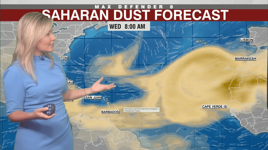
The weather in the southern United States has been influenced by a high-altitude layer of dust from Africa known as the Saharan Air Layer. This layer affects the weather patterns by breaking up storms and hurricanes. Jason Dunion, a meteorologist from the University of Miami working with NOAA, describes it as a thick layer that begins about a mile above the earth. He explains that these dust layers travel from Africa every three to five days during the summer, with each one roughly the size of the contiguous United States as they move across the Atlantic Ocean.
The peak season for Saharan dust is typically from mid-June to mid-August, which can alter the usual weather patterns across the U.S. It creates a warm, dry air mass that suppresses the formation of thunderstorms and hurricanes by limiting atmospheric growth. This suppression could explain the slow start to the hurricane season this year.
Meteorologist Rebecca Barry at WFLA showcased a significant plume of Saharan dust in August 2026, unusual for such a healthy plume this late in the season. Ordinarily, such a plume would appear in late spring or early summer.
The presence of this dust can minimize the formation of tropical storms and hurricanes, affecting weather patterns significantly. Without the typical summer storms, southern U.S. regions are experiencing elevated temperatures, with heat indexes reaching as high as 110 degrees.
Beyond just the southern states, Saharan dust extends its influence into places like Texas and Arizona, as observed by KXAN meteorologist Freddy Vela. The dust also contributes to vibrant sunrises and sunsets by scattering light, producing intense colors in the sky. Dunion finds the journey of the dust remarkable, covering 3,000 to 4,000 miles across the Atlantic and still visible in the U.S.